| Participatory Mapping | |
 |
CSDi Partner Prem Goolaup, of the Island of Mauritius in the Indian Ocean, has been developing a community based adaptation project for the past eight months. The adaptation components of his project include a Soil Restoration and Water Management Program and a farmer workshop on early maturing crops varieties for adapting to climate variability. |
He has developed these adaptation components for his project because farmers in the village of La Chaumière are suffering from poverty due to a reduction in crop yields caused by climate variability:
- Increasing number of intense tropical cyclones
- Shift in the start of the rains – starting later and ending earlier
- Drought: long dry spell in October, November and December
- Unpredictable rainfall during the rainy season
- Increased intensity of rainfall in between longer dry spells
- Flash floods
His farmer’s adaptation strategies include:
- getting more organic matter into their soil to better hold water
- using mulches to reduce evaporative loss
- composting
- water conservation techniques
- water management techniques during periods of heavy rain and flooding
- drought resistant and early maturing crops varieties
- buffering techniques to protect plants against unpredictable rainfall
- techniques for protecting young plants during torrential rains and flooding
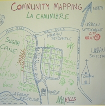
He’s using a participatory mapping technique to not only learn more about the specific challenges the farmers face, but by including them in the research and drawing of the map, they are better understanding their current challenges and also developing a sense of ownership for the project.
“The workshop was about drawing a participatory community map especially indicating farmlands and water sources. It went on well, people voluntarily contributed information and the resulting map was quite good. We tried to include each and every plot as far as possible. We also noted the existing infrastructure, the potentially vulnerable areas, the risks and hazards. This map pictured a good baseline of where the community is now. As the project finishes in about two years time it will indicate how well we performed.”
To learn more about this participatory mapping workshop that Prem held with the farmers you can see his homework assignment complete with photographs here.
Prem’s long-term impacts of the project:
100 agricultural households near La Chaumière village have surmounted the cycle of poverty and now lead a productive, meaningful and prosperous lives.
Prem’s near-term outcomes for the project:
Families at La Chaumière village adopt climate resilient agricultural practices through soil restoration and water management program which increased production, improved overall welfare of the community and ensured food security.
Farmers at La Chaumière adopt good overall farming practices by developing greater resilience to climate variability through adopting drought resistant crops and buffering against weather variability practices which increased production, and help villagers to be prosperous, productive members of their communities.
To learn more about the course, visit OL 344.
Do you think that engaging subsistence farmers suffering from the hazards of climate change in a participatory mapping exercise is a good idea?
Learn how to develop a community centered, impact oriented project.