Gillian Primus (Grenada), Hanna Bartel (Canada), and Meredith Waters (US) have been working for the past year on a project on the island of Grenada; Granada has been hit by a series of tropical hurricanes and tropical storms that are exhibiting increased ferocity over the past seven years. This has led to reduced crop harvests, a reduction in food security, increased malnutrition, and increased poverty.
The team originally developed this project outline to increase crop production, and then identified highly specific sub activities to target highly specific in-field challenges.
Their simple project outline:
Farmer Soil Conservation and Water Conservation and Management Program [Solution to underlying causes: Climate variability, extreme weather, and unpredictable rainy season have reduced crop harvests]:
[Activity 1]. Farmer workshop on soil restoration and conservation techniques
[Activity 2]. Farmer workshop on water conservation and management techniques
[Activity 3]. Participatory mapping and identification of local soil and water challenges in preparation for future implementation phase
Dual challenge– drought and flooding: This team working on a project in Grenada is currently developing sub activities for their project that on the one hand will help farmers during drought conditions—and on the other hand can protect the fields from flooding.
The workshop introduced six different types of agricultural techniques that would be useful for the community, based on our research of results in similar contexts. As such, the materials we have gathered so far should be enough for this introductory workshop, and we are relying on the extension agent to know all the details! We have developed a lesson plan to guide the workshop.
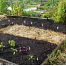
| Identification of specific project sub activities: Raised Beds |
|
 |
The workshop was about soil restoration and conservation for smallholder farmers. Our team was joined by the agricultural extension officer that we usually work with and had worked with us on the participatory mapping workshop—Michael Mahon. The workshop began with a conversation about why they, the farmers need to restore and conserve their farms soil—and then we discussed low-cost/no-cost activities that they could do beginning today. |
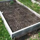
| Plot division experiment with soil temperature and moisture content |
|
 |
We asked Mr. Mahon to speak in “layman’s language” on what soil is made of, its composition, types and characteristics with emphasis on clay soil, organic matter, nutrients, and beneficial flora and fauna. Mr. Mahon then demonstrated some very simple hands-on soils tests that we all did together that allowed us to see what the makeup of their soil was (we asked each farmer to bring a little can of typical soil from their farm field). This let them see what the condition of their soil was in, how much loam was left after erosion, and how much organic material as well. |
|
We then looked at examples of different kinds of organic materials that are available in and around the village. These range from crop residues (in this case the stalks of the pigeon peas and corn plants), to leaves, animal manure, and grasses. |
|
| Mulching experiment: | |
 |
Mr. Mahon then did the demonstration where he divided a part of the plot of soil into 4 squares. The participants also with Mr. Mahon lined the edges of one with bricks and placed a piece of glass on top, sprinkled a thin layer of mulch on the second one, sprinkled a thick layer of mulch on the third square—and left the fourth square bare. We returned an hour later to look at how hot the surface of the soil was in each of the four squares—and what the level of soil moisture was and then had a very lively discussion about the results.. |
|
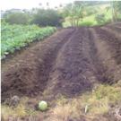
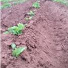
After lunch we then began the session on composting by building a compost heap with materials that we had put on site before the workshop—all the while discussing what compost was, how to make it, and what its benefits were. The day before we had a couple of farmers prepare half of the demonstration plot the way they usually do for planting. We then demonstrated a conservation agriculture approach in the second half of the plot and created deep bedding with gullies between them. In this final exercise the farmers planted their half and we planted the other. The farmers plot was left bare (as they would normally do) and we covered our plot with mulch. The demonstration plot will be monitored over the next few months to see how the two planting techniques compare with each other. |
|
|
Raised bed with sweet potatoes prior to mulching
|
|
 |
|
You can download the participatory mapping for their project here:
OL 333 assignment one how-to card.
You can download their full project outline here:
OL 343 assignment five
You can download the workshop photos here:
OL 333 assignment eight farmer workshop.
Here are some of the techniques that they’re using:
Drought and rain related to erosion:
-get more organic material into the soil by incorporating crop residues back into the soil prior to planting
-use crop residues to mulch on the surface of the soil so that it is not so exposed
-collecting organic material and making compost piles
-building barriers in the field to retard the movement of water off of the field
-contour ridges
-making raised planting beds
Agricultural techniques for high rainfall and flooded areas
Wet Watershed Management Guide: Water Harvesting and Soil Conservation in High Rainfall Areas
-agroforestry/alley cropping
-contour farming
-mixed cropping
-deep bedding system
-gully plugging – earthen gully plugs
-graded bunds
-field bunds
-protection bunds
-farm ponds
-drainage channels and culverts
-diversion channels
-land reclamation and vegetative measures
Deep Bedding Systems for Improved Drainage Description:
Digging deep drains and piling the excavated soil between the drains give rise to deep beds 2-2.5 ft high which may necessitate the construction of side walls. Breaking up the soil manually to a fine tilt is next followed by the incorporation of organic matter to improve soil fertility and structure. Can be labor intensive. Good DRM practices for Belizean small farmers
Would you like to learn how to develop Community Based Adaptation Projects?
Please write us with your stories, thoughts and comments through Online.Learning@csd-i.org