Kenya: Climate Smart Agriculture
Joyce Onyango (Kenya), Aramide Adebola (Nigeria), and Natalie Macawaris (Philippines) have been working for the past year on a project in Kenya. Extreme weather events began 30 years ago in 1980 with a drought and famine called ‘Gorogoro’. These droughts and famine increased in frequency and intensity. These droughts and famine cycles have reduced from 20 years (1964-1984), to 12 years (1984-1996) to two years (2004-2006 and to yearly (2007/2008/2009).
Recently they conducted a participatory vulnerability and capacity assessment with the community:
What is a prioritization of the community’s greatest hazards they face?
-Change in the timing of the growing (rainy) season; it seems to be starting later and ending earlier
-Drought; August had always had a two or three week dry spell in the middle of the rainy season — that dry spell is becoming much longer
-Unpredictable rainfall during the rainy season
-Occasional (every third year) extreme tropical storms
Vulnerability Matrix: What parts of their lives (livelihood resources) are the most vulnerable?
-Food Security
-Well-Nourished Children
-Income Generation
The team originally developed this project outline to increase crop production, and then identified highly specific sub activities to target highly specific in-field challenges.
Their simple project outline:
Climate Smart Agricultural Practices Programme [solution to underlying cause: Lack of knowledge of climate smart/improved agricultural practices; Climate variability]:
[Activity 1]: Surveys and interviews to collect traditional knowledge on agriculture, changes in agricultural cycles, vulnerabilities and coping strategies
[Activity 2]: Identify expert specialist/extension agent in soil, water and agriculture to design and facilitate participatory workshops
[Activity 3]. Community workshop on participatory mapping of water and land resources and uses, agricultural challenges and vulnerabilities—and degraded hotspots
[Activity 4]. Extension agent visits most affected farmers to identify exact CC impacts to crop production and needs of farmers to adapt to the impacts (diseases, droughts and floods)
[Activity 5]: Develop plan that combines resilient and improved agricultural techniques with traditional knowledge for an overall improvement in productivity
[Activity 6]: Establish pilot plots demonstrating better cultivation practices
[Activity 7]. Workshops on crop diversification and drought resistant crops.
[Activity 8]: Farmer workshops on soil restoration and conservation techniques
[Activity 9]: Farmer workshops on water conservation and management techniques
Farmer Extension Program [Solution to underlying causes: Inadequate information.]:
[Activity 1]. Information mapping and identification of local crop and buffering challenges
[Actvity 2]: Packing and disseminating climate change related information to communities through government and communities collaboration
[Activity3]. Farmer workshop and follow-up on early warning systems
[Activity 4]. Establishment of local based vernacular radio programme on issues of climate change, credit facilities and coping mechanisms.
Workshop using specific Sub-Activities
In October they held a capacity building Community workshop on development of Water and Soil Restoration and Conservation Techniques” at Ojola in Kisumu North District that targeted 12 Committee members who have been consistently in participatory project mapping and development. This resulted from what farmers had already done a few months ago: Participatory Mapping and Identification of Local Soil and Water Challenges. So this is when now the community presents basic Soil Restoration and Conservation techniques which will enable farmers to get sound foundation before moving on to more exciting aspects of the project.
Activities carried out during the workshop included:
-Development of compost manure
-Planting of Napier grass
-Seed bed establishment
-Mulching for retaining soil moisture
| Activity 1: Development of compost |
|
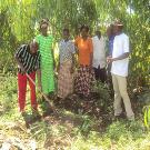 |
The materials used to make the compost included maize stalks, lantana camara, dry grass, kitchen waste, manure, among other materials. They were put in layers that were finally covered with black polythene paper and stick put vertically which will be used to test when the fertilizer is ready for use. |
Activity 2: Napier Grass Planting |
|
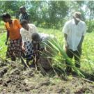 |
Participants again went through Napier grass planting along the farm stretch to avoid erosion. This was considered very important for water conservation and management as a technique among other furrow constructions and building barriers to retard the movement of water off the fields. Napier stalks were collected and cut in the same sizes ready for planting. The stretch was prepared by digging around the demonstration farm and finally planting took place as demonstrated below |
Activity 3: Seed Bed Preparation |
|
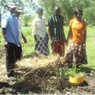 |
Development of a seed bed was done by the committee members, an agricultural initiative meant for planting horticultural crops while the garden is still being prepared to retain the lost nutrients. The seedbed contains variety of seedlings of different vegetables separated per variety. The seedbed is prepared through digging and thorough harrowing is done to make the soil fine. The soil is mixed with compost for nutrient addition before planting seedlings. The seedlings are watered on a daily basis in the morning and evening until they are transplanted into the main farm. The seedbed contained tomatoes, onions, carrots, dania (parsley), and kale among other vegetables. |
|
|
|
|
Activity 4: Mulching
|
|
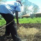 |
Mulching was considered a very essential activity to retain soil moisture. The farmers mulched the field for improved soil moisture conservation. This was again meant to contribute a solution to the challenges of poor farming practices like no cover cropping nor conservation agriculture practices to retain the lost moisture |
How to Card Mapping of Farmers Agricultural Risks Vulnerabilities and Hazards.
You can download their full project outline here:
OL 343 assignment five
You can download their vulnerability assessment here:
OL 333 assignment two vulnerability assessment.
You can download the workshop photos here:
OL 333 assignment eight farmer workshop.
Would you like to learn how to develop Community Based Adaptation Projects?
Please write us with your stories, thoughts and comments through Online.Learning@csd-i.org
One comment